


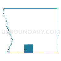
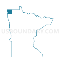
Davis Twp. Voting District, Kittson County, Minnesota
About
Outline

Summary
| Unique Area Identifier | 602764 |
| Name | Davis Twp. Voting District |
| County | Kittson County |
| State | Minnesota |
| Area (square miles) | 35.33 |
| Land Area (square miles) | 35.27 |
| Water Area (square miles) | 0.06 |
| % of Land Area | 99.84 |
| % of Water Area | 0.16 |
| Latitude of the Internal Point | 48.59428570 |
| Longtitude of the Internal Point | -96.83446190 |
Maps

Graphs
Select a template below for downloading or customizing gragh for Davis Twp. Voting District, Kittson County, Minnesota


Neighbors
Neighoring Voting District (by Name) Neighboring Voting District on the Map
- Augsburg Twp. Voting District, Marshall County, MN
- Donaldson Voting District, Kittson County, MN
- Donnelly Twp. Voting District, Marshall County, MN
- Jupiter Twp. Voting District, Kittson County, MN
- Sinnott Twp. Voting District, Marshall County, MN
- Skane Twp. Voting District, Kittson County, MN
- Spring Brook Twp. Voting District, Kittson County, MN
- Svea Twp. Voting District, Kittson County, MN
- Tegner Twp. Voting District, Kittson County, MN
Top 10 Neighboring County Subdivision (by Population) Neighboring County Subdivision on the Map
- Jupiter township, Kittson County, MN (111)
- Augsburg township, Marshall County, MN (74)
- Spring Brook township, Kittson County, MN (52)
- Svea township, Kittson County, MN (49)
- Tegner township, Kittson County, MN (48)
- Skane township, Kittson County, MN (46)
- Donaldson city, Kittson County, MN (42)
- Davis township, Kittson County, MN (30)
- Sinnott township, Marshall County, MN (24)
- Donnelly township, Marshall County, MN (19)
Top 10 Neighboring Place (by Population) Neighboring Place on the Map
Top 10 Neighboring Unified School District (by Population) Neighboring Unified School District on the Map
- Tri-County School District, MN (2,116)
- Kittson Central School District, MN (2,050)
- Stephen-Argyle Central Schools, MN (1,961)